
In early June, Launceston survived a flood scare. The levee banks held; it was a close call.
The Tamar River is a tidal estuary that ends right on the edge of Launceston city centre. Here is a map of the Tamar:

Here is a map of Launceston:

Two fresh water rivers, the North Esk (from the top right of the map) and South Esk (from the bottom left) empty into the very end of the Tamar, and around which Launceston is built.
The South Esk flows through the Launceston Gorge, a remarkable natural feature within walking distance of the city centre. About one kilometre before it reaches the Tamar, The Gorge opens up to form The Basin, a popular recreational area. Then it narrows again to a precipitous but spectacular valley opening up right at the Tamar edge, a perfect funnel for flood waters.
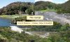
The two fresh water rivers flood from time to time due to heavy rain in the catchment areas far from Launceston itself. When they flood they carry extraordinary volumes of water. The main photo at the top of this post shows The Basin in calm times and then during a ‘minor‘ flood (several years ago).
At low tide the swollen rivers are less of a problem. However, when the tidal waters swell in from Bass Strait, they combine with the excessive flood waters from the Esk rivers.
Here is a very interesting link about the June 2016 floods with some dramatic videos and other interesting links. Floods in Launceston and northern Tasmania, June 2016.
It includes two photos of The Basin from the other side, before and after flood.
Tab down the page and check the video, taken by drone, under the caption: “Back in Launceston, the flooding in the Tamar basin was incredible“. It shows how the water rushes in from the South Esk (via The Gorge) then churns past the North Esk (where the silos are).